In the Works
A Digital Journal from San Francisco Public Works
OCTOBER 2026


The Rest of the Lineup

NUMBERS
2026 YTD (through the end of September)
by the

447
blocks resurfaced

18958
TREes PRUNED

17773
tons of debris collected

5144
potholes filled

352
curb ramps constructed

A vehicle operated by urban tree intelligence company greehill, outfitted with powerful sensors and cameras, drives through Bernal Heights.
Lasers, Not Legs: How Public Works Is Counting Every Street Tree
The sun had been up for more than an hour, bathing Precita Park in a mild, late-October glow, but for Conor Nolan’s workday to begin in earnest – mapping San Francisco’s expansive urban forest at the speed of light – it had to rise to the right angle.

Greehill navigator Conor Nolan explains how the vehicle’s technology works.
The magic number: 25 degrees above the horizon.
“This gives us the best photos that we pair with the point cloud data,” he said, standing near his pickup truck, outfitted with powerful sensors and cameras to capture every San Francisco street tree.
A navigator with urban tree intelligence company greehill, Nolan and his colleagues are helping Public Works turn millions of light beams into detailed 3D images – or point clouds – of street trees.

A side-by-side image shows a tree in real life and as a point cloud.
For the first time in a decade, San Francisco is counting every street tree in the City – and for the first time ever, it’s doing so with LiDAR. Short for Light Detection and Ranging, LiDAR uses pulses to capture precise measurements, painting a vivid, data-rich picture of the City’s urban forest for Public Works arborists. It’s a fitting approach for the tech capital of the world.
“It's definitely cutting edge in terms of the way that we would be looking at tracking our urban forest,” said Charlie Murphy, assistant superintendent for trees with Public Works’ Bureau of Urban Forestry, which cares for San Francisco’s street trees. “It’s going to allow the City to create its ... tree maintenance efforts in a strategic, data-driven way, which is going to, one, save us money and, two, be much more cohesive in our approach to tree maintenance.”
Public Works’ urban forestry crews know San Francisco’s topography all too well.
During their last tree inventory, they teamed up with City partner SF Planning, the nonprofit Friends of the Urban Forest and contractor tree inventory specialists to walk San Francisco’s tangle of narrow alleys, wide boulevards and winding side streets – a task that took a full year and covered much of the City’s 47 square miles. The tally then: Some 125,000 street trees across San Francisco.

Before this year, tree inventories were done on foot. Here, Jacari Jacobs, a Public Works intern in 2021, surveys a Coast Live Oak near Sanchez Street.
For Public Works’ latest tree mapping effort, they are saving their legs. And time.
In partnership with greehill, the urban tree intelligence company, Public Works earlier this month kicked off its most comprehensive – and speediest – street tree inventory undertaking to date.
For nearly a month, seven days a week, from 9 a.m. to 5 p.m. (or whenever the sun crosses its 25-degree threshold), a trio of greehill vehicles with LiDAR-powered tech has been crisscrossing the City.
The tree counting sprint happens at no more than 23 mph to make sure the car’s two sensors – emitting a combined 3.6 million light beams per second – can get the full picture. Also mounted atop the vehicles is a 360-degree camera, affectionately known as “the ladybug,” that takes a photo every 5 meters. Each vehicle collects a gargantuan 1 terabyte of data – the equivalent of storing 200,000 or more standard smartphone photos – per day.

The two sensors atop the vehicles send out a combined 3.6 million light beams per second.
Software then processes the data, using AI to turn each tree into a verified “digital twin,” a virtual model with more than 70 standardized data points.
Those details cover everything from a tree’s size and structural stability to its overall health, how much clearance it has from nearby sidewalks, streets and buildings, and the climate and environmental benefits it provides.
That’s a big leap.
In past surveys, City teams could measure a tree’s trunk diameter, crown width and, depending on its size, sometimes its height – by hand. LiDAR goes much further, capturing crown volume, leaf surface area and density, trunk stability, the percentage of dead wood and each tree’s overall vitality.

The newly harvested data will give arborists a wealth of information.
Not only that, but conventional tree surveys can be subjective to a certain degree, said Murphy, the Public Works assistant superintendent for trees. This high-tech method helps weed out some of the judgement calls that can happen ordinarily.
“It allows us to see a lot of different trends in way more of a specific data-driven way than it is anecdotal with people collecting data,” Murphy said.
To be sure, expert arborists’ diagnostics remain essential but their time in the field is limited. LiDAR frees the same urban forest staff to focus on assessing and caring for trees and it allows Public Works to update the inventory far more often.
Because every tree is measured the same way, in every neighborhood and every time it’s scanned, Public Works can compare trees against what’s typical for their species, flagging those whose structure, leaf area or other features fall outside the normal range. That helps the Bureau of Urban Forestry prioritize unhealthy, dead and overgrown trees. The analysis will be available next year, providing arborists the information they need to fine-tune their tree maintenance efforts.

A greehill vehicle drives through hilly Bernal Heights.
The inventory will also help the Bureau of Urban Forestry target and track work by its in-house arborist crews and more accurately assign and trace contractor tree work.
“This is going to allow us to essentially see every tree in a month and then capture that data so that we can equitably target our tree work around town,” Murphy said. “And I think that's super important.”
Over time, it will allow the City to plan budgets more accurately, track how the urban forest changes and move faster toward its canopy goals.
With repeat scans, the Bureau of Urban Forestry will be able to keep a close eye on how different species are faring across the City’s microclimates, insight that until now has been largely anecdotal.
“This is the only place I’ve ever been where you plant certain species on the west side of town versus the east side because of the fog,” Murphy said. “We’ll be able to map that and determine, okay, this is the line for fog-appropriate species.”

Greehill navigator Conor Nolan looks at a screen that displays the data collected in real time.
San Francisco’s idiosyncrasies were not lost on Nolan, the greehill navigator, either.
Rolling up and down Bernal Heights’ narrow one-way streets and navigating its tight turns, a galaxy of bright turquoise, dark blue and pale green dots flashed across a screen mounted to the truck’s center console – each Bernal Heights block driven spawning tiny digital blocks on the display. His next stop: the Excelsior.
After nearly a month of meticulously motoring through the City, it felt familiar. A perk of the job in some ways.
“What keeps things interesting is that every neighborhood, every street layout is different, especially in San Francisco,” Nolan said. “You get to see the heartbeat of a place, which I really enjoy... You all have some really beautifully wooded streets. And, you know, driving every street in a place, you get to know it better than some residents.”

Public Works’ landscape crews go over the game plan before planting the hillside adjacent to Sunset Boulevard.
The Great ReScape:
Landscape Maintenance Methods Reimagined
At the northern tip of Sunset Boulevard, on the west side of the road, Public Works Bureau of Urban Forestry landscape crews got to work on a recent fall morning, clearing non-native grassy weeds from a small patch of hillside to create a blank canvas for planting.
Standing nearby was Jennifer Cooper, who manages the department’s Bureau of Landscape Architecture.
“I rolled out a plan, grabbed a circle template and colored pencils, and got to work on the still-warm hood of a Public Works truck to sketch a plan,” Cooper said.

Jennifer Cooper, who heads the Public Works Bureau of Landscape Architecture, sketched the planting plan for the ReScape project.
She based the design on her team’s previous work along other sections of Sunset Boulevard. “We already had a proven palette of California natives that we knew could thrive in the sandy soil of this protected, south-facing hillside,” Cooper said.
And the Bureau of Urban Forestry landscape team also had on hand 10 oaks from acorns gathered on San Bruno mountain and 10 California buckeyes to anchor the hillside tree canopy. Around the trees, crews were poised to plant a broad swath of evergreen shrubs and perennials: ceanothus, toyon, coyote brush, sticky monkeyflower, yarrow, artemisia, buckwheat and seaside daisy.
With the plan in hand, the choreography began.
First, the landscape crew – 38 workers strong – laid a sheet of cardboard on the barren ground. Next, they piled atop a layer – about three inches thick – of mulch cultivated from fallen and pruned street trees. And finally, the crew tucked plants through openings in the cardboard to help suppress invasives and give the new native landscape a head start.

Crews lay down cardboard sheeting before piling woodchips on top to help prevent weeds.
The operation was part of a special department-sponsored training through a certification program run by ReScape, a San Francisco-based nonprofit that focuses on regenerative landscaping methods that restore, replenish and improve the nature-based landscaped land.
Using cardboard and mulch to prevent weeds, for example, is more time-consuming than simply spraying chemical herbicides to kill them up front. But the long-term benefits are clear.
“The ReScape system improves the health of the soil and the plants, reduces water use and allows for better weed control,” said Ron Hostick, the Bureau of Urban Forestry assistant superintendent who oversees landscape crews.
With the City under mandate to wean off the use of herbicides and deploy them only as a last resort, Public Works has been incorporating other strategies to control weeds and maintain landscaped property. That’s where the ReScape training – a mix of philosophy, science, law and practical application – comes in.
The curriculum included three days of classroom instruction and one day of hands-on experience last month. The training covered a lot of ground – plant and tree selection, habitat creation, pest management, water reduction, local environmental conditions, irrigation, principles of environmental stewardship, soil biology, carbon sequestration and a lot more – before they headed out to Sunset Boulevard for the field component.

Freshly planted young plants and trees start to take root on the reimagined hillside.
Hostick said a key component of the training was to bring more context to the work the crews do every day.
“It’s about the why of why we do things instead of just directing them to do it without reference,” he said.
Public Works cares for just over 265 acres – or more than 11.5 million square feet – of landscaped medians across San Francisco. The goal is to make the ReScape model the go-to operational strategy.
Hostick said that about 80% of the landscape team, which has some 80 employees, has been trained in regenerative landscape maintenance. The method was recently put into practice along the Alemany Boulevard median.
Cooper, the Public Works landscape architecture bureau chief, said the work performed during the ReScape training on Sunset Boulevard was another key step in achieving the City’s long-term goal of creating a biodiverse greenway that stretches 2 miles between Lake Merced and Golden Gate Park on the west side of San Francisco.
“A lush native habitat corridor, buzzing with pollinators, alive with birdsong and punctuated by places for community life,” she said.
That small patch improved during the ReScape exercise, Cooper said, “was just one hillside. But it felt a little like planting the seeds for the whole boulevard.”

Thousands of sandbags are on hand at the Public Works Operations Yard for pickup by San Francisco residents and businesses.
Sandbag Operation Gearing Up for Storm Season with Special Pop-Up Distribution Events
Like a churning cauldron, a potent stew of unusually warm oceanwater is brewing in the central and eastern tropical Pacific Ocean. And though hundreds of miles away, San Francisco is bracing for its potential impact this fall and winter.
As forecasters, with increasing confidence, warn of a very strong El Niño – the recurring climate pattern that can influence seasonal rainfall, ocean temperatures and coastal weather hazards in California and elsewhere – City officials are working to batten down the hatches and prepare for the possibility of an active storm season. Although El Niño does not guarantee severe storms or flooding, it does increase the potential for significant weather impacts.
The City is coordinating with the National Weather Service, the California Office of Emergency Services, utility companies and community partners to ready for winter weather and coastal flooding. Gov. Gavin Newsom last month issued a state of emergency to bolster statewide preparedness and Mayor Daniel Lurie declared a local emergency earlier this month to allow departments to secure goods and services needed for El Niño preparations more quickly.

Public Works Director Carla Short speaks at a press conference about the City’s storm preparations.
And Public Works – as a leading department charged with responding to and cleaning up after severe storms – has been gearing up, too.
“Preparing for and responding to storms is in our DNA at Public Works,” said Public Works Director Carla Short. “The ongoing close coordination with our City, regional and state partners, as well as clear communication with the community, is paramount to ensuring that public safety remains our top priority.”
Throughout the year, Public Works offers free sandbags to residents and businesses who frequently experience flooding. From 8 a.m. to 2 p.m., Monday through Saturday, anyone in need can pick up sandbags at the Public Works Operations Yard at the Marin Street/Kansas Street gate. There is a 10-sandbag limit per address.
Additionally, Public Works will host a series of targeted sandbag giveaway events on several Saturdays in November and December, including:
-
Nov. 7, 8 a.m. to 2 p.m., Marina Green Triangle, Marina Boulevard at Marina Green Drive
-
Nov 14, 8 a.m. to 2 p.m., Lake Merced Area, Sunset Circle Parking Lot, Sunset Boulevard at Lake Merced Boulevard
-
Nov 21, 8 a.m. to 2 p.m., Marina Green Triangle, Marina Boulevard at Marina Green Drive
-
Nov 21, 8 a.m. to 2 p.m., Ocean Beach Parking Lot, Great Highway at Balboa Street
-
Dec 5, 8 a.m. to 2 p.m., Sherman Street, between Folsom Street and Harrison Street
-
Dec 5, 8 a.m. to 2 p.m., Fire Training Center, 19th Street and Folsom Street

The Public Works Sandbag Saturdays flyer.
For more information about sandbags, visit: sfpublicworks.org/sandbags
While El Niño is not a single storm or a series of storms, Public Works and sister agencies are preparing for the potential of increased rainfall and coastal flooding this fall and winter.
The National Weather Service outlook favors wetter-than-normal conditions in Northern California for December 2026 through February 2027, with the heaviest rains potentially peaking in January.
Data released earlier this month by a major seasonal model showed that San Francisco’s precipitation forecast for January is clocking in at 5 inches above normal. From December through March, the model’s average forecast runs at nearly double its normal rainfall in San Francisco. That means instead of a typical 13 inches of rain from December through March – San Francisco may see 26 inches.
Among forecasters’ biggest worries, however: coastal flooding.
San Francisco set multiple high tide records for October, which typically has the least extreme tides of the year due to gravitational alignments of the moon and sun. The tides recorded earlier this month were in the range more typical of winter king tides.
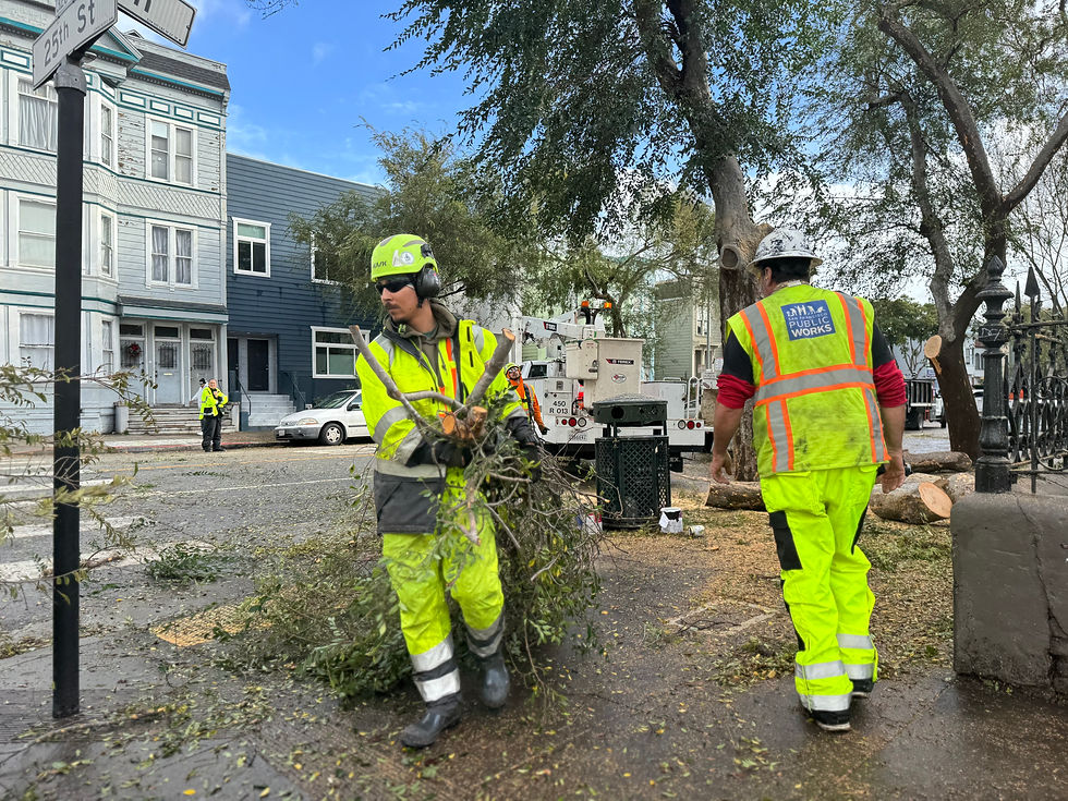
Public Works Bureau of Urban Forestry crews clean up a storm-damaged tree.
Wind, too, is a concern during storm season.
One of Public Works’ biggest tasks during and after storms is clearing roads and sidewalks of debris and making sure damaged trees don’t pose a danger to people or property.
Tree crews stand at the ready to deal with hazardous trees and broken or fallen branches and limbs to make sure roads and sidewalks remain safe and accessible. Public Works also will bring in contractor tree crews to pitch in if needed.
Additionally, department engineers are prepared to assess and respond to landslides to keep the public safe and street cleaning crews clear leaves and litter from storm drains before and during severe weather to help prevent localized flooding. Public Works street resurfacing teams will jump into action to make road-related repairs when potholes invariably pop up in increased numbers after prolonged, intense storms.
Key to the department’s response work is the Public Works Radio Room, a 24/7 operation that triages all requests that come in from 911 and 311 and dispatches them to appropriate Public Works staff or partner City agencies.
Community members should report non-emergency localized flooding and downed trees to 311 so crews can address the issue. Residents should contact 911 for downed power lines and life-threatening situations.
Public Works also encourages people to sweep up leaves and litter in front of their homes and businesses to keep debris from filling the storm drains.
“We will continue preparing across City departments and I’m asking every San Franciscan to do their part so we can keep our communities safe – because the time to prepare for a major storm is before it arrives,” Lurie said.

A cable car passes by the shrink-wrapped Chinatown Public Health Center on Mason Street.
Shrink-Wrapped and Storm-Ready
Take one look at the Chinatown Public Health Center – a fixture at the western edge of Chinatown for more than 50 years – and you’ll notice something’s different: It’s been shrink-wrapped.
The white plastic film encapsulating the outside of the City building was added as part of the massive overhaul of the seismically vulnerable health clinic, just in time for the upcoming winter storm season.
“The building is shrink-wrapped to provide general weather protection, allowing the contractor to proceed with exterior work, while minimizing weather-related impacts,” said Public Works Project Manager Youcef Bouhamama, noting it also helps contain dust and debris.

Hazardous materials-removal specialists hand-scrape old fireproofing
from roof overhang beams at the health clinic.
The 30,000-square-foot health center, located at 1490 Mason St., sits atop the Broadway Tunnel. Crews are working both inside the tunnel, which has partial lane closures to support construction, and inside the building where they are methodically removing hazardous materials.
The Chinatown Public Health Center modernization project will include a full seismic retrofit to strengthen the San Francisco Department of Public Health facility. Additionally, the renovation will integrate primary and medical care with mental and behavioral health services, expand dental care, increase the number of exam and consultation rooms, improve accessibility with barrier-free access, upgrade restrooms, include elevator enhancements and provide air quality and ventilation upgrades.
This is the clinic’s first major modernization since it opened in 1971. The project broke ground this past summer and is scheduled to be completed in spring 2029. San Francisco Public Works is managing the upgrades, as well as leading the architectural design. Suffolk Construction is serving as the contractor.

A young volunteer builds a wooden brace to support a newly planted street tree.
#LoveOurCity
As temperatures soared toward 90 degrees, 81 community volunteers sizzled with energy to green and clean the Richmond District for this month’s Love Our City: Neighborhood Beautification Day workday. The group included 16 students from Sutro Elementary School who planted street trees and spruced up their campus grounds.
Neighborhood Beautification Day, hosted by the Public Works Community Engagement team, is a monthly volunteer workday that brings together residents, nonprofits, local businesses and Public Works employees who work together on community improvement projects. Participants weed and plant medians, wipe out graffiti, repaint street furniture, pick up litter and plant street trees.

Community volunteers spruce up the grounds of Sutro Elementary School.

Raine Lee, left, shows off her NBD All-Star certificate, which she just received from Public Works Director Carla Short, right.
At this month’s event on Oct. 3, we also honored our latest NBD All-Star: Raine Lee. A high schooler in Alameda, Raine crossed the Bay six times this year to join in the workdays, which she attends with her father. She’s attended many more in past years.
Read more about NBD All-Stars here.
Next month marks the final Neighborhood Beautification Day of the 2026 season, where the focus lands on Noe Valley, Glen Park, the Castro, Diamond Heights and other District 8 neighborhoods. Kickoff for the Nov. 7 event is set for 9 a.m. at James Lick Middle School, 4161-25th St.
Whether you’re a first-time volunteer or a seasoned hand, we’d love to see you there.


A HALLOWEEN HARVEST

Grown from seeds at the Public Works Street Tree Nursery in SoMa, this pumpkin is ready for Halloween.

Street Tree Nursery Manager Chris Reed waters the small garden.