
In the Works
A Digital Journal from San Francisco Public Works
MAY 2026

Feature Story
A new tool – which uses a method called LiDAR, short for Light Detection and Ranging – allows Public Works staff to survey buildings and sites much faster than before. The new technology also enables designers and engineers to catch mistakes early, swiftly assess a space and virtually size up a structure.


The Rest of the Lineup
City Rolls Out Traffic-Safety Upgrades Along Eastern Waterfront
This month, Public Works joined Mayor Daniel Lurie, District 6 Supervisor Matt Dorsey and our partners with the San Francisco Municipal Transportation Agency to cut the ribbon on the Terry Francois Boulevard Bike and Pedestrian Safety Project.


NUMBERS
2026 YTD (through the end of April)
by the

155
blocks resurfaced

2394
TREes PRUNED

8335
tons of debris collected

2765
potholes filled

114
curb ramps constructed

Public Works Architectural Assistant KC Lin walks along the cable car barn in Nob Hill to map the site using a new scanning and surveying tool.
LiDAR, Camera, Action: New Tool Helps Public Works Level Up Its Architectural Surveying
Floating above the Heron’s Head Park EcoCenter in the Bayview, Damon Louie dove into a vast sea of colorful dots.
As he descended deeper, olive green spots slowly grew into shrubs, bright beige flecks rolled out walkways and peach-colored specks assembled the center’s walls.

A screenshot shows a 3D image model of the EcoCenter, which was mapped with the help of the new scanning and surveying tool.
With the click of a button, Louie, the Computer-Aided Drafting and Building Information Modeling Manager at Public Works, teleported into the EcoCenter – a Port of San Francisco-owned space for environmental education and public outreach that is undergoing an infrastructure and accessibility upgrade. Public Works is leading the effort.
The expansive galaxy of so-called point clouds on Louie’s computer screen was the product of a new wearable scanning and surveying tool that emits lasers to measure distances in the real world and ultimately produce a detailed 3D image model – a point cloud.

The wearable scanning and surveying tool is outfitted with a chest-level display screen.
“You can imagine that when we were doing projects, if we didn’t have this kind of technology, we’d have to take quite a bit of notes and images and be able to organize it into something that we can understand,” Louie said. “But with this we know exactly where we took the image because it literally places you at the site.”
The virtual world that unfolded on his monitor gives Louie and his architecture and landscape architecture colleagues the ability to roll out a digital tape measure to size up a structure, isolate and analyze a floor to see how level it is, glide through walls to swiftly assess the site, take and inspect certain cross-sections of a project and, perhaps most importantly, marry building plans, models and existing drawings with the new scan of a particular space in order to design improvements, spot potential conflicts and check for inconsistencies.

Public Works colleagues Damon Louie (left) and KC Lin inspect a corner of the San Francisco Municipal Transportation Agency’s cable car barn in Nob Hill.
“It saves us from needing to constantly go on site if we forget something,” Louie said. “You can see it’s pretty detailed.”
The tool – which uses a method called LiDAR, short for Light Detection and Ranging – holds great promise to cut down on the time it may take to survey a building and site, which, in turn, means Public Works teams can scan and survey more projects. And save money. All to the benefit of sister departments that partner with Public Works and, ultimately, taxpayers.
“It’s a very accurate tool and it saves time on both our end and the clients’,” said Aries Martin, an architectural associate and job captain with Public Works. “Overall, it shows how much more efficient we’ve become.”

The wearable scanning and surveying tool uses LiDAR sensors that are rigged to float overhead and at hip height.
Getting a sensor for it
LiDAR technology is not new.
Researchers use it to produce more accurate shoreline maps. It helps scientists study our atmosphere. And, recently, autonomous vehicle companies have tapped it to paint 3D pictures of their cars’ surroundings.
But to better understand the way this particular tool is leveling up Public Works’ mapping abilities, it’s best to think of the way modern smartphones take panorama photos: one smooth side-to-side pan to capture the whole mountain range – instead of snapping multiple, individual photos and stitching together each peak.
It used to be, Louie explained, that he and his colleagues would employ tripod-based, stationary LiDAR scanners to survey a particular space. That meant setting up the scanners over and over and over and over again to take measurements and snap 360-degree photos, which then would have to be pieced together manually to complete the bigger picture.
On a big project that could mean setting and resetting the two tripods hundreds of times, with each individual scan taking seven minutes, resulting in a multi-day effort.
“So, in the old days, this actually was pretty time-consuming and laborious,” Louie said. “In addition to doing the scans, we also have to process the data afterwards.”
But now, the brand-new scanning tool – which uses software known as SLAM, short for Simultaneous Localization and Mapping – does it all at once.

Public Works Architectural Assistant KC Lin traces the outside of the cable car barn to map the site using a new scanning and surveying tool.
To survey a space, a person simply slips into the body-worn metal frame – outfitted with a chest-level display screen and LiDAR sensors, similar to the ones atop a Waymo, that are rigged to float overhead and at hip height – and starts walking.
“We will wear a backpack and it will scan everything in real time, put everything together in real time,” Louie said. “And we will come back, we upload the data set and then we do some more processing. It significantly reduces the hours compared to our old stationary scanners.”
Mapping the EcoCenter site and its surroundings took Louie no more than an hour and a half. He estimates that, in general, the tool cuts down the time needed to scan a site by about 75%.

A screenshot shows a 3D image model of the EcoCenter, complete with so-called point clouds.
Aside from speed and precision, the new technology has the potential to allow designers and engineers to catch mistakes early.
Take, for instance, a project built with steel beams and frames. Louie and his colleagues can go and scan the site, then come back and superimpose it onto a structural model.
“When we overlay the two together, we can see if there are any discrepancies,” he said. “Like: Did they put the columns in the right place or beams in the right place? We have a comparison of our intended design with what’s actually built. We put them together and we look for double vision, we look for discrepancies and that can tell us ... how the construction is going, if there are any errors.”
Not only can the tech help catch mistakes, it also can aid in situations where designers don’t have all the background and context they need. That, in part, is what happened with the EcoCenter.
There are some surveys from a long time ago, said Public Works Landscape Architect Associate Janet Kiyoi, but they don’t have all the information the team needs, including complete as-built drawings of the building.
“(This tool) can help fill in the gaps of some of the information that we need to complete our renovation work,” she added.

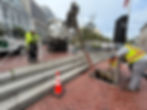
Public Works staff get the lay of the land at the cable car barn before scanning the site.
Walking the walk
With the Transamerica Pyramid piercing a dense fog in the distance and cables for the City’s most famous mode of transportation whirring through the tracks in the wet asphalt nearby, Public Works Architectural Assistant KC Lin – an in-house reality capture specialist – fastened the new scanning tool to his waist on a damp morning earlier this year. He then performed a meticulous choreography.

Public Works colleagues KC Lin (left) and Damon Louie trace the outside of the cable car barn to map the site using a new scanning and surveying tool.
At the San Francisco Municipal Transportation Agency’s cable car barn in Nob Hill, he slalomed between cable cars parked inside, traced the building’s brick facade and looped through empty back lots, carefully scanning the site.
The cable car barn, located at Mason and Washington streets, stores and powers the City’s fleet of cable cars and houses staff to support and maintain the only-in-San Francisco operation. The site is also home to a cable care museum, which is free and open to the public.

Public Works Architectural Assistant KC Lin slaloms between cable cars parked inside the cable car barn as he scans the site.
Public Works’ Bureau of Architecture, in partnership with the SFMTA, completed the master plan to renovate the entire building in 2022, including upgrading the electrical room, conducting seismic retrofitting, improving accessibility and revamping the restroom and locker facilities. The Public Works architecture team is currently working on the schematic design for the electrical room upgrade.
“SFMTA is very excited about this scanning tool,” said Public Works Architect EunJoo Cho, who is the project lead on it.
Because it’s a historic building, the cable car barn is a prime candidate for the new technology. “The one thing it’s especially good for is historic buildings,” Martin said.

Public Works Architectural Assistant KC Lin maneuvers through the cable car barn as he scans the site.
That’s because historic structures often have design intricacies that are difficult to capture with conventional measuring methods. “There’s a level of detail you just can’t document otherwise,” Martin said.
In addition to the Heron’s Head Park project, Martin has used the tool on several others, including work at the War Memorial Opera House where Public Works is installing a platform lift for wheelchair users.
“Even though it was a small area, it made more sense to scan it than to measure everything by hand,” Martin said.
Beyond project size, the tool has also proven valuable for capturing small but important details – like ceiling diffusers, which are used to evenly distribute hot or cold air.
Architects often create reflected ceiling plans, which map out everything on the ceiling – lighting, vents and other fixtures. Missing something as simple as a diffuser can mean an extra site visit.

The cable car barn stores and powers the City’s fleet of cable cars and houses staff to support and maintain them.
“With this, you can just open the program and look up at the ceiling – you immediately see everything that’s there,” Martin said. “You can study it and all the information is right in front of you.”
Outside the cable car barn, meanwhile, the old-fashioned cable cars dutifully rattled up and down the hilly streets framing the 139-year-old building, while giant wheels inside drove the cables that pull them along their routes. And Lin, charting his own path, slowly walked the perimeter, a high-tech scanning rig snapped to his waist.
Mapping the future, one dot at a time.

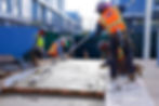
Public Works engineer Una O’Neill (left) watches crews pour low carbon concrete as part of the Buchanan Street Mall Renovation Project.
A Concrete Way
to Build Greener
Like a sand-colored stream of lava, concrete steadily billowed out of a thick black hose on a chilly May morning in the Western Addition, laying the groundwork for a transformational renovation of a decades-old park and gathering space.
Patiently, the viscous mass crept in between the rebar grid and sidled up against the wooden forms holding it in place. As if trudging through quicksand, crews in hard hats and reflective vests waded through the concrete-filled rectangles, scraping shovels across the wet surface to spread out the material and flinging heaps of it from one end to the other. With the help of hammers and vibrating tools, they made sure to leave no air pockets as the nascent structures took shape.
To the naked eye, the concrete pours – creating retaining walls for a future playground and a ramp and stairs to a new performance stage as part of the Buchanan Street Mall Renovation Project – looked like any other. A central plank of most construction projects, a routine foundational step at sites across the City.
But this specific kind of concrete is built different. Literally.

Crews pour low carbon concrete near a new performance stage as part of the Buchanan Street Mall Renovation Project.
Through its special makeup, a mixture that uses less carbon-intensive cement and instead substitutes other more climate-friendly materials, it constitutes an alternative to conventional concrete. Expanded use of the material is part of a green-building revolution – from solar panels to mass timber – that aims to reduce any given project’s carbon footprint and tamp down greenhouse gases, like carbon dioxide or CO2.
“The cement part of concrete creates a lot of CO2 emissions, and that’s what we’re trying to avoid from an environmental, global warming standpoint,” said Jennifer Cooper, Public Works’ landscape architecture bureau manager and a member of the department’s climate action team.
Concrete is made up of rocks, water, air and cement, with the latter acting as a glue. The key to low carbon concrete is swapping some of the cement part with other materials, such as fly ash or slag.
“Replacing that cement and modifying it actually is a secret sauce to lowering carbon emissions,” said Brian Reyes, senior circular economy coordinator with the San Francisco Environment Department.
In the case of the Buchanan Mall Renovation Project – a long-overdue makeover of the pedestrian walkway and City park that runs on a traffic-free stretch of Buchanan Street, from Eddy Street to Grove Street – officials estimate that using low carbon concrete will translate to a reduction in carbon between 20-30% compared to a build using conventional materials.
Once the pours wrap up, Reyes and his team – who are tracking the pilot project – will have hard numbers to measure the climate impacts.
Public Works is leading the design of the project and managing construction on behalf of the Recreation and Park Department, which is managing the overall project and operates the park. Aside from a fully redesigned open space with a playground, performance areas and a walkway featuring local art, the project also includes underground sewer improvements and new green infrastructure, including rain gardens to capture runoff and help prevent localized flooding, in collaboration with the San Francisco Public Utilities Commission.
“This project is a very good example of a community-driven design process, from planning through construction,” said Public Works landscape architect Brett Desmarais, the lead designer on the effort. “The site programming, thematic development, involvement of local artists – it's all done to reflect the contributions and ideas of the community and with their direct involvement.”

Crews pour and shovel low carbon concrete to build a ramp for a new performance stage.
Small tweaks, big impacts
Known as low carbon concrete, the building material for the park refresh is hardly new. Projects at San Francisco International Airport have made use of it. Private construction across the City has tapped into it without fanfare.
What’s different about the five-block Buchanan Street revamp is that it represents a collaborative effort among City agencies to consciously chart a course toward using the climate-friendly material from the jump. And as much of it as feasible.
“Our aim with this project is to model a process and to build a public space that both the community and the City are proud of,” said Lauren Dietrich Chavez, project manager with Rec and Park, who likened the park to a “front porch” for the community.
In many ways the project embodies the perfect storm of interagency coordination, a shared goal and the right timing.
For starters, Cooper, the Public Works landscape architecture bureau chief, said she and her colleagues realized that a lot of the industry was already moving in the direction of low carbon concrete. “So we started to look at modifying our standard specifications,” she said, referring to the technical framework – or “specs” – the department provides to contractors who bid on projects.
While Public Works staff was working on recalibrating its construction standards and guidelines for contractors to move toward greener building, Reyes joined the San Francisco Environment Department from Marin County where he had just finished their low carbon concrete specification standards.
Additionally, Chavez, the project manager on the Buchanan Street renovation for Rec and Park, “was really excited about exploring low carbon concrete,” Cooper said. “So it really felt like everybody was coming together on this as an idea for changing our standards in the City but also using this project as a great example for that work.”
At first blush, the internal modifications to Public Works’ guidelines may seem subtle. But the reconfigured standards, Cooper said, will have far-reaching impacts on all kinds of public projects, exponentially stacking up climate benefits.
Whereas previously Public Works specified that contractors could use up to a maximum percentage of alternative materials like fly ash or slag, the department is now shifting toward performance-based requirements, which encourages contractors to use as much of the climate-friendly material as feasible as long as it meets the performance criteria.
Put another way: A shift from “you can use it,” to “you must use it to meet our performance metrics.”
“We work on hundreds of projects throughout the year, most of which include pouring concrete,” Cooper said. “Whether it’s in the right of way, the structure for buildings, public open space – so reducing that percentage of CO2 emissions is huge when you add it up.”
At Buchanan Street Mall, with some small exceptions, nearly all the concrete being poured is of the low carbon variety.
Going forward, how much any given project will be using low carbon concrete may depend on the type of work – a bus pad may have different requirements than a park retaining wall, for instance. “You do the maximum amount possible while still meeting the needs of the City and the project,” Cooper said.
Importantly, however, not only does low carbon concrete perform as well as conventional concrete, it’s also a price match. “Adding low carbon concrete actually didn’t raise the cost,” Cooper said, referring to the Buchanan Street project.
There is one quirk though.
“As a landscape architect, what was interesting that I hadn’t anticipated was just how it affects the color of concrete,” said Cooper, adding that slag in the mixture, for instance, makes the material much brighter.
In the case of the park renovation, Desmarais, the Public Works landscape architect, had to work with the contractor on the mix percentages to get the color right, she said.
The takeaways from the pilot will inform how Public Works designers prepare for projects that aim for certain aesthetics going forward.

Low carbon concrete is poured to form structures for the park refresh.

Crews smooth out freshly poured low carbon concrete.
Crews shape freshly poured low carbon concrete to build a ramp for a new performance stage.
‘A central part of their community’
While low carbon concrete is the star of the construction process at the new and improved Buchanan Street Mall, the end product is still intended to be a refreshed park with all the usual trappings – from native landscaping to appropriate lighting.
“It will feel very green compared to what’s there now,” Cooper said.
Construction started in April 2025 and is expected to wrap up by fall. Once complete, the renovated park will feature two new playgrounds, picnic and barbeque areas, a half and a full basketball court, communal gardens, an art plaza and a performance stage.
The slender, north-south open space was built by the then-San Francisco Redevelopment Agency and opened to the public in 1975. A year later it was transferred to Rec and Park.
The park underwent major renovations in the late 1980s and early 1990s and received repairs in the early 2000s. After years of underuse, a slew of improvements followed in the mid-2010s before a vision plan was completed in 2017 after extensive community outreach and input from residents.
“The community used to think of this park as like a central part of their community and we heard that in the groundbreaking that they used to really love it,” said Una O’Neill, Public Works’ resident engineer on the project. “And then for years it’s been more derelict and unsafe... And so I think just giving it a revamp will be nice to give it back to the community.”
To O’Neill, who studied environmental engineering in college, seeing sustainability in action in the form of low carbon concrete has been exciting, too.
“It’s kind of good to see things actually get put into practice,” she said.
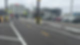
Pedestrians and bicyclists use the new protected pathways along Terry Francois Boulevard. Photo credit: Arianna Cunha, Port of San Francisco
City Rolls Out Traffic-Safety Upgrades Along Eastern Waterfront
The stretch of San Francisco waterfront connecting the Mission Bay and Dogpatch neighborhoods has undergone an eye-popping transformation in recent years with the construction of the new Mission Rock development, the opening of a new arena and the creation of bayside parks. And with that evolution has come a burst of activity crowding both the roads and sidewalks.
This month, Public Works joined Mayor Daniel Lurie, District 6 Supervisor Matt Dorsey and our partners with the San Francisco Municipal Transportation Agency to cut the ribbon on the Terry Francois Boulevard Bike and Pedestrian Safety Project. San Francisco Giants mascot Lou Seal hopped on a two-wheeler to test ride the new bike lane.
The multi-agency effort aims to improve safety and accessibility on the busy corridor between China Basin Park, just south of Oracle Park, and Mission Rock Street, north of Chase Center.
The makeover creates a safer route for people walking, biking and rolling. Among the improvements:
-
New asphalt paving throughout the corridor
-
Clearly defined roadway striping and signage for pedestrians, cyclists and drivers
-
Concrete barriers separating bike lanes from vehicle traffic to prevent encroachment
-
Accessibility upgrades to support people with disabilities
-
Narrowed driveway crossings to reduce conflicts between vehicles and active transportation users
Lou Seal tests the new bike lane.
The Port of San Francisco-funded project was designed and constructed by City crews from the Port, the SFMTA and Public Works.
The Port led project scoping, visioning, funding, outreach and interagency coordination and installed the physical concrete barriers protecting bike lanes. Public Works paved the roadway and provided engineering services, while the SFMTA led roadway design and installed striping, signage and pylons. The Giants contributed accessible crossing treatments to enhance pedestrian safety near the ballpark.
“Streets are essential infrastructure in our urban fabric – serving as the arteries that connect our neighborhoods and the people who live, work and visit here,” said Public Works Director Carla Short. “Making them safer, more accessible and more inviting is a top priority that we as a city are committed to deliver on.”

City officials cut the ribbon for the Terry Francois Boulevard Bike
and Pedestrian Safety Project.
Public Works crews work on a deep clean for the United Nations Plaza and its fountain.
UN Plaza Fountain Scrub-Down
On most Mondays of the year, Public Works crews fill the United Nations Plaza fountain with fresh water. But once a year, we team up with a specialized contractor to perform a deep-cleaning operation.
Working with vacuum trucks and by hand with scrapers, sprayers and other tools, crews remove all the grime, goop and trash that accumulates in the inner workings of the public fountain, scouring the sculptural water feature inside and out.

Crews remove all the debris that accumulates
in the inner workings of the public fountain.

Public Works crews tackle the area beneath the plaza for their cleaning operation.
The surrounding red-brick plaza, which Public Works already cleans daily, also got a more focused cleansing.
In 1975, United Nations Plaza was dedicated within the San Francisco Civic Center Historic District to commemorate the founding of the United Nations 30 years earlier at the nearby Herbst Theatre in the War Memorial Building.
As conditions in San Francisco’s urban core have changed since then, there have been calls on and off to remove or revamp the fountain – over the objections of preservationists – but no plans have advanced. Meanwhile, Public Works crews will continue to clean and maintain the fountain on a regular basis.

The specialized operation comes on top of
Public Works’ more routine cleanings.

Public Works crews and volunteers shovel mulch during this month’s Love Our City: Neighborhood Beautification Day workday.
#LoveOurCity
Scores of volunteers joined forces with Public Works crews for this month’s Love Our City: Neighborhood Beautification Day workday, cleaning and greening the Mission, Portola and other District 9 neighborhoods.
After a brief kickoff at Garfield Square Park, participants split up into teams and tackled a range of improvement and beautification projects, from removing invasive plants from picturesque hillsides to wiping out graffiti tags along 24th Street and picking up litter along busy Mission District corridors.

A Neighborhood Beautification Day participant hauls away green waste on a hillside in Bernal Heights Park.

Volunteers pick up litter as part of this month’s greening
and cleaning effort in District 9.
Every month, Neighborhood Beautification Day focuses on a different supervisorial district, bringing together residents, community groups, merchants and Public Works employees to improve San Francisco neighborhoods.
Next month’s Neighborhood Beautification Day will be held on June 6 in the Sunset, Parkside and other neighborhoods in District 4.

A Public Works employee and a volunteer team up
to paint out tags in the Mission.

Volunteers remove invasive plants from a hillside in Bernal Heights Park during Neighborhood Beautification Day.
We welcome both seasoned community volunteers and newcomers of all ages. The day will get started at 9 a.m. at the Sunset Boulevard median, at 1453-36th Ave. For more information, and to sign up, please visit our volunteer website or click below.

